


Col du Chat

PhilippeC54
User
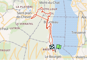

Length
18.9 km

Max alt
886 m

Uphill gradient
934 m
Km-Effort
31 km

Min alt
232 m

Downhill gradient
934 m
Boucle
Yes
Creation date :
2022-06-03 08:12:49.63
Updated on :
2022-06-03 09:58:40.105
1h19
Difficulty : Easy

FREE GPS app for hiking
 SityTrail
IGN / Geographical institutes
SityTrail Plus
The world is yours!
About
Trail Road bike of 18.9 km to be discovered at Auvergne-Rhône-Alpes, Savoy, Le Bourget-du-Lac. This trail is proposed by PhilippeC54.
Positioning
Country:
France
Region :
Auvergne-Rhône-Alpes
Department/Province :
Savoy
Municipality :
Le Bourget-du-Lac
Location:
Unknown
Start:(Dec)
Start:(UTM)
723054 ; 5059509 (31T) N.
Comments